TROPICAL CYCLONE WARNING.
FORECAST CENTRE, INSMET.
Date: 5 November 2024. Time: 06:00 am.
Rafael intensifies in the Caribbean Sea
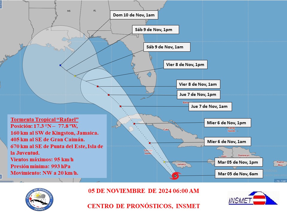
During the early hours of this morning, Tropical Storm Rafael, located in the central Caribbean Sea has gained in organisation and intensity. The maximum sustained winds increased to 95 kilometres per hour, with higher gusts, the minimum central pressure dropped to 993 hectoPascal.
At 6 a.m. the central region of the Tropical Storm was estimated at 17.3 degrees North latitude and 77.8 degrees West longitude, a position that places it about 160 kilometres southwest of Kingston, Jamaica, 405 kilometres southeast of Grand Cayman Island and 670 kilometres southeast of Punta del Este, Isle of Youth. It is moving on a near northwesterly course with a translation speed of 20 kilometres per hour.
In the next 12 to 24 hours this system will continue to move with a similar course and speed of translation, approaching the vicinity of Jamaica. During its displacement it will continue to gain in organisation and intensity and could reach the category of hurricane near the Cayman Islands. Rain, showers and thunderstorms will continue in the eastern and central regions, which may be heavy and intense in some locations. Rainfall will later extend to western Cuba. The effects of the wind and the sea in the different regions of the country will depend on the trajectory and intensity reached by this tropical cyclonic organism.
Taking into account the current position and future trajectory of this organism, the greatest attention should be paid to its evolution, the possible impacts on the national territory and the information issued by the Forecast Centre of the Institute of Meteorology.
The next tropical cyclone warning for this system will be issued at noon.


