The Meteorological Institute reports in its TROPICAL CYCLONE WARNING No.8 that during Tuesday night and early this morning, Hurricane Beryl has continued its rapid movement to the west-west, with a translation speed that has decreased slightly to 31 kilometres per hour.
Winds in the upper levels of the atmosphere have remained unfavourable for its development, which together with the presence of dry air has resulted in its slow weakening during this period.
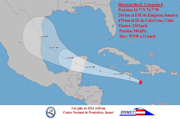
It continues to be a hurricane of great intensity, category four on the Saffir-Simpson scale, with maximum sustained winds of 230 kilometres per hour, with higher gusts. Its minimum pressure has risen to 946 hectopascals.
The centre of Hurricane Beryl was estimated at six o’clock this morning at 16.7 degrees north latitude and 74.7 degrees west longitude, a position that places it approximately 260 kilometres east-southeast of Kingston, Jamaica and 470 kilometres southeast of Cape Cruz, Granma.
Over the next 12 to 24 hours, Beryl will continue to move on a similar track, slowing slightly, approaching Jamaica late Wednesday morning, where it should cross in the early afternoon. Its centre will be very close to or over the south of Jamaica. The weakening trend should continue, although it will remain a major hurricane during this period.
On its path through the seas to the south of eastern Cuba, there will be an increase in winds in the eastern region, which in the afternoon of today may reach sustained speeds between 40 and 55 kilometres per hour with higher gusts in the south of Granma. In the rest of the eastern region winds will be between 20 and 35 kilometres per hour, with higher gusts. From the early hours of Thursday morning and early Thursday morning, the wind force may increase in Isla de la Juventud and the western end of the country, with speeds between 30 and 45 kilometres per hour, with higher gusts.
In the eastern region, clouds will predominate, with showers, rain and some thunderstorms, which may be strong in some localities, mainly in mountainous areas. In the late afternoon and evening some showers may also occur in the south of the central region, due to the circulation of the outer bands associated with this cyclonic organism, where heavy rains are not ruled out.
There will be swells on both coasts of the eastern region, which from the afternoon will increase to strong swells in the south of Granma and the coastal area of the Guamá municipality in Santiago de Cuba, with light to moderate coastal flooding. These swells will extend from early Thursday morning to the south of the centre and then to the west in the morning of that day, where they will become strong in the south of Isla de la Juventud, the Canarreos archipelago and the western end of Cuba, with light to moderate coastal flooding in low-lying areas of this coastline.
The next tropical cyclone warning for this system will be issued at 6 p.m. today, Wednesday.