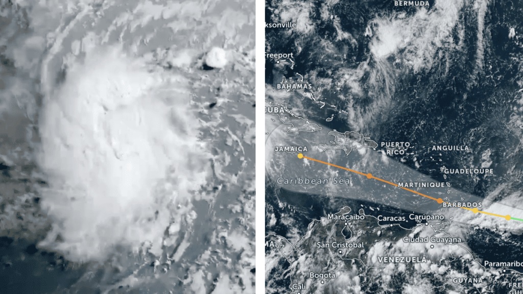
The Lesser Antilles are maintaining red alerts today due to the passage of category 4 hurricane Beryl, which reached the Windward Islands on Monday with sustained winds of over 200 kilometres per hour.
Faced with this powerful, premature and unusual cyclone, which intensified from 1 to 4 on the Saffir Simpson scale in less than a day, the Government of Grenada declared a state of emergency as of 19:00 local time this Sunday in anticipation of the arrival of Beryl, which is expected to hit the island.
Meanwhile, all inter-island ferry sailings between Trinidad and Tobago were cancelled for Monday, while Barbados Prime Minister Mia Amor Mottley urged all non-essential businesses on the island to shut down on Sunday night in anticipation of the hurricane’s arrival.
The Trinidad and Tobago Meteorological Service issued a red alert for the island of Tobago indicating that a major impact is very likely and instructing residents to take immediate action to protect their lives, livelihoods and property.
This is in addition to the nationwide closure, also on Sunday night, of St Lucia, which will remain in that condition in the face of Beryl’s imminent arrival, the island’s prime minister, Philip J. Pierre, announced.
«Businesses and schools will remain closed on Monday, the premier said, urging people to stay indoors until further notice of normalcy.
Grenada’s Maurice Bishop International Airport has also been closed since 18:00 local time and is tentatively scheduled to reopen Tuesday morning.
In Barbados, Grantley Adams International Airport has announced the same, as have St Lucia’s Hewanorra International Airport and George F. L. Charles Airport.
Another report from the US National Hurricane Centre said the Government of the Dominican Republic issued a tropical storm warning from Punta Palenque westward to the Haitian border.
Beryl became the first hurricane of the current Atlantic hurricane season, and will go down in history as one of the most unusual and dangerous, another warning after the first storm, Alberto, reaffirming a complex period.
In less than 24 hours Beryl moved from one category to another with ease and its maximum sustained winds ranged from 56 to 215 kilometres per hour between Saturday afternoon and Sunday.
Official data indicate that Beryl is the earliest major hurricane (category 4 so far) to form in the Atlantic in 58 years, and the earliest to originate east of the Lesser Antilles (where storms tend to form later in the summer when waters are warmer).
Before the current Atlantic cyclone season began on 1 June and is due to end on 30 November, several experts warned of exceptionally warm ocean waters that may increase tropical storms in the Caribbean and Gulf of Mexico.
Meteorologists at the University of Miami, Florida, in the United States, say that in the Atlantic region – where most hurricanes develop – water temperatures are unusually high and warm oceans act as an octane booster for the hurricane season.
This increase provides the necessary fuel for the formation and intensification of hurricanes and tropical storms as they move over the ocean.
According to data from the Climate Reanalyzer at the US University of Maine, global average sea surface temperatures in the North Atlantic reached 22.3 degrees Celsius at the end of May, exceeding the 1982-2011 average by 1.3 degrees Celsius.
A report from the same institution stresses that warm water in the Gulf of Mexico was a major factor in storm surges such as Hurricane Katrina and is associated with heavy rainfall in storms such as Harvey and rapid intensification.


