Cuba is the birthplace of meteorologists who make history. The Caribbean island has given the world outstanding meteorologists whose work has elevated the country’s scientific prestige internationally. Among them stands out meteorologist Dr. Aldo Moya Álvarez, originally from Cienfuegos and currently based in Lima, Peru; his career is leaving a significant mark on meteorology.
For instance, we owe the algorithms used today for calculating humidity variables in the Cuban Meteorological Institute’s network of weather stations to Dr. Moya’s research.
Despite the distance, Dr. Moya maintains close collaboration with Cuban specialists. Daily, he provides us with two runs of the WRF (Weather Research and Forecasting) model implemented by him and recognised for its high effectiveness in meteorological predictions. His expertise in this field has been key to optimising forecasts in the region.
As a researcher and lecturer at the National Agrarian University La Molina, Dr. Moya specialises in developing and implementing numerical models for weather forecasting and has over 20 articles published in high-impact international journals indexed in SCOPUS and Web of Science.
Among his most recent milestones is the development of the innovative «early forecast» model for the AMA-20 hurricane season, whose results have demonstrated remarkable precision, reinforcing its utility for risk management.
inter aldoAldo Dr. Aldo Moya
As a dedicated educator, he continually shares his knowledge, as he did recently by presenting his analyses on the development of the hurricane season and future projections to the public.
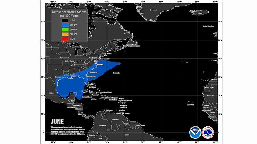
The 2025 Atlantic Basin hurricane season has begun with particular characteristics meriting detailed analysis. According to Dr. Moya, this year saw the latest-forming first named tropical cyclone since 2014, when Tropical Storm Andrea finally formed on 24 June, followed by Tropical Storm Barry on the 28th. «These two systems exhibited typical characteristics of June tropical cyclones: both were relatively weak and short-lived,» explains Dr. Moya.
This peculiarity is not coincidental, as the expert notes: «June, as the first month of the Atlantic hurricane season, is precisely characterised by hosting low-intensity, ephemeral tropical cyclones.»
Dr. Moya’s analysis reveals fundamental data on June cyclone dynamics: «The formation area during this month is not extensive and is largely surrounded by land, which significantly limits both the duration and development of these systems.»
Statistics support this observation: the average formation of tropical cyclones in June for the period 1975-2024 is approximately one per year, with an average lifespan of around four days, resulting in minimal contributions to the season’s Accumulated Cyclone Energy (ACE) Index.
Addressing the key question of whether June’s behaviour can predict the season’s subsequent development, Dr. Moya offers a detailed statistical analysis: «Although the number of tropical cyclones formed in June alone does not determine whether the season will be active or not, there are interesting statistical correlations.»
The expert highlights that in the last 20 seasons (2005-2024), years recording two tropical cyclones in June (2005, 2012, 2013, 2016, 2017, and 2020) averaged 20.16 tropical cyclones per season. More revealing is the Pearson correlation coefficient of 0.44 between the number of cyclones formed in June and the annual total for 1975-2024 – «a not insignificant value considering June is a month of low cyclone activity,» notes Moya.
The meteorologist adds: «If we built a statistical forecast model based solely on the June cyclone count – which would clearly be insufficient – the projection for this 2025 season would be approximately 16 tropical cyclones.»
Furthermore, he emphasises that serious seasonal statistical models must consider all named tropical cyclones, regardless of intensity or duration. «In meteorology, we must uphold scientific rigour above preferences or passions. Although spectacular events attract more attention, all named systems provide valuable information for our predictive models,» asserts Dr. Moya, categorically rejecting any suggestion that the National Hurricane Center (NHC) might falsify classifications: «It would be utterly unprecedented and contrary to the fundamental principles of our scientific discipline.»
Based on Dr. Moya’s analysis, we can therefore conclude that an above-normal hurricane season is indeed expected, as also forecast by other prestigious institutions in this field, while remaining mindful that the evolution of atmospheric and oceanic conditions in the Atlantic Basin over the coming months will have the final say.
On 5 July, concluding the article, Tropical Storm Chantal formed off the southeastern coast of the United States. Chantal is the third named storm of the current hurricane season. According to the US hurricane specialist Philip Klotzbach, on average, the third named storm in the North Atlantic basin forms on 3 August.