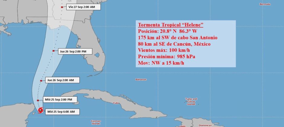
Tropical Storm Helene, during the early morning has continued to gain in organisation and intensity, has maximum sustained winds that have increased to 100 kilometres per hour, with higher gusts and its minimum pressure has dropped to 985 hectopascals. It has moved in the last few hours on a northwesterly course, decreasing its speed to 15 kilometres per hour.
The rains associated with Helene have mainly affected the west of Cuba and at this hour are extending towards the central region. The heaviest accumulations from 8 p.m. last night until 5 a.m. today are reported in: Punta del Este, Isla de la Juventud with 101 millimetres, Paso Real de San Diego with 78 millimetres, Pinar del Rio with 72 millimetres and Isabel Rubio with 70 millimetres, all in the province of Pinar de Rio.
At six o’clock this morning, the central region of the tropical storm was estimated at 20.8 degrees north latitude and 86.3 degrees west longitude, a position that places it about 175 kilometres southwest of Cape San Antonio, the western tip of Cuba, and 80 kilometres southeast of Cancun, Mexico.
Over the next 12 to 24 hours, it will continue to move across the western Caribbean Sea, tilting its path to the north-northwest in the early morning hours, slightly slowing its speed. Helene will continue to gain in organisation and intensity, and may become a hurricane this morning, very close to entering the Gulf of Mexico.
The rains will continue in the western and central regions of Cuba, which will become heavy and intense in some localities, and may persist until Thursday.
Tropical storm force winds will be reported in Isla de la Juventud and Pinar del Río, with speeds between 55 and 70 kilometres per hour, which may extend in the morning to the province of Artemisa. In the extreme west of Cuba, the wind will increase in strength from the early hours of tomorrow. In the rest of the western provinces, speeds will be between 40 and 55 kilometres per hour, with higher gusts.
There will be swells on the south coast of the provinces from Pinar del Río to Sancti Spíritus, reaching strong swells south of Isla de la Juventud and the Canarreos archipelago, as well as on both coasts of the province of Pinar del Río, with light to moderate coastal flooding on the south western coast.
In areas of showers and thunderstorms there may be an increase in wind strength and wave height, even in areas far from the centre of circulation of this tropical storm.
The next tropical cyclone warning from this agency will be issued at noon today, Wednesday.